Cities
When cell towers are overloaded
In a major incident, thousands of calls compete for the same towers. The mesh runs alongside and is not affected by the congestion.
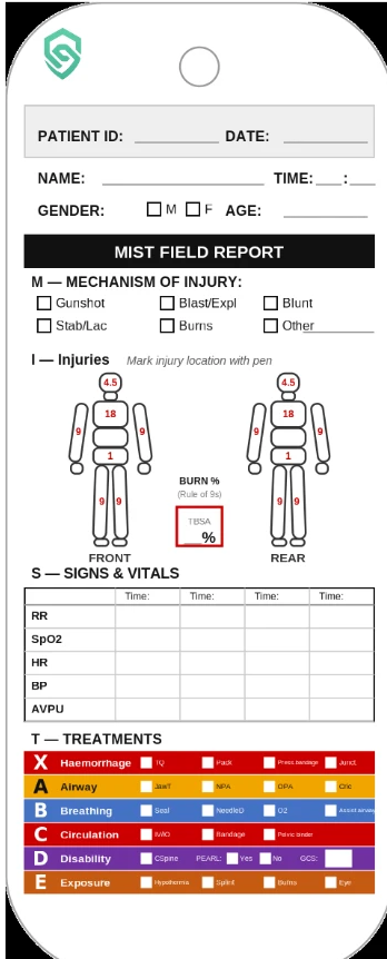
Guardian Chain links physical triage tags to a digital patient record, so everyone in the chain of care sees the same picture, in real time.
Håll muspekaren över eller tryck för att vända
In a mass casualty incident, police, healthcare, fire and rescue services and the Armed Forces work at the same time – with different tools and each with only part of the picture.
Today
Command post
With Guardian Chain
Command post
What is noted at the scene does not always reach the next link in the chain of care.
Command lacks a combined view of patients, priorities and where they are.
As casualties increase, priorities and transports are planned on incomplete information.
The tag ID connects the scene, the collection point, transport and receiving care. Every link sees the same record.
Step 1 · Haemorrhage
PRIO 1
Scan or tap the card
MCI-000042
Step 1 · Haemorrhage
PRIO 1
Scan or tap the card
MCI-000042
Triage
The patient gets a pre-printed triage tag with a QR code and an NFC chip. The priority is visible on the tag.
I — INJURIES
HR
–
—
SpO₂
–
—
BP
–
—
T — TREATMENTS
X
TQ14:03
A
B
C
D
E
Timeline
Scan
The tag is scanned or tapped with a phone and linked to a digital record. Nothing is written down twice.
I — INJURIES
HR
–
—
SpO₂
–
—
BP
–
—
T — TREATMENTS
X
TQ14:03
A
B
C
D
E
Timeline
Follow
The record travels with the patient. Treatments and vital signs are logged in transit, even without coverage.
I — INJURIES
HR
–
—
SpO₂
–
—
BP
–
—
T — TREATMENTS
X
TQ14:03
A
B
C
D
E
Timeline
Receive
Receiving care sees who is on the way, at what priority and what has been done – before arrival.
Lead
A shared operational picture of the scene, updated in real time for all involved responders, provides the basis for faster decisions and better resource allocation.
Small nodes in the field, a hub on site and the cloud when there is a connection. Each layer works on its own.
Share position and reports over an encrypted LoRa mesh, with no mobile coverage at all.
Keeps everything local and encrypted, runs the operational picture and uses 5G when available.
Syncs when a connection is available and gives command and follow-up a combined view.
The hubs use 5G and mobile networks when they are available. When they are not, their own encrypted mesh network takes over – LoRa, with up to 10 km between hubs and nodes depending on terrain.
In a major incident, thousands of calls compete for the same towers. The mesh runs alongside and is not affected by the congestion.
Mobile coverage does not reach tunnels and platforms. Nodes pass reports on hop by hop until they reach a hub.
Concrete and rebar block signals. Nodes in stairwells and on each floor form a chain up and out of the building.
Long distances and few towers. With up to 10 km per hop, one hub can cover a large area on its own.
The people in charge see where hubs and nodes are and how they reach each other – so resources can be placed where they are needed.
Few steps, large touch targets and clear roles. The system supports the tags – it does not require paper to disappear.
CCP
The physical tag carries the information even when the technology does not.
Everything works on the device and syncs when a connection is available.
Patient data is stored encrypted, on site too.
The record is event-based, so every action can be traced afterwards.
From first assessment to the receiving hospital.
An overview of casualties during the response.
The same picture of the situation as everyone else.
Works where regular infrastructure is missing.
In development
We invite agencies to run pilots with Guardian Chain and evaluate the system in their own operations. If your organisation wants to run a pilot or learn more, get in touch.
Prototypes
Done
Verification
In progress
Pilots and exercises
Next